North East Hayling
Residents Association
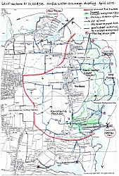
See the map for our area (click to enlarge), showing part of the report and exhibition held at Havant Borough Council recently. We have highlighted the current shoreline, the western edge of the proposed 'managed retreat', and shown the land which would be lost should this plan was to go ahead. This is further inland than has ever been located before. Also marked on is a very approximate location of the highest contour, before the land slopes back to the village. Essentially under a 'managed retreat' a new sea wall will be built further inland as part of the first epoch (first 15-20 years ) This would then be maintained and raised on this line for the next 2 epochs (periods of time).
The NEHRA Sea Defence representatives have met and discussed the problems with the draft plan with Natural England, the Environment Agency and Havant Borough Council and have made a response on behalf of NEHRA.
NEHRA have a number of concerns about each of the 3 sectors which are summarised below.
Sector 1 – Langstone Bridge to Northney Farm - Plan Recommends Hold The Line:
Overall the decision to ‘Hold the Line’ is acceptable. However the details of how this can be achieved are lacking. Holding the line is important because otherwise the main entrance to Northney is cut off during very high tides and storms.
Sector 2 – Northney Farm – Plan Recommends Managed Realignment:
This is the sector where there are the most problems.
- The loss of Northney Marshes would have a huge impact on rainwater collection for our area. The salt marsh is the collection area for all the rainwater from much of Northney Farm and a big proportion of the NEHRA area. Rainwater also collects in this reservoir from the Southern Water surface water sewers from roads in Northney and then discharges via ditches to the marshes. The plan does not consider where this rainwater will collect in the future should the salt marsh be lost.
- When the tidal flaps are closed and the ditches backfill in very heavy rainfall, flooding does occur to houses and the pumping station by Gutner Lane.
- The salt marsh area also makes good pasture for the beef cattle for the Three Harbours beef scheme. The loss of the salt marsh could affect this scheme and the viability of the farm. This in turn would affect the whole of the Northney and Tye community and way of life.
- An irreplaceable SSSI site would be lost should the realignment in this area go ahead.
- Rainwater from fields on to the roads also brings down some of the topsoil, thus eroding its quality.
Sector 3 - Gutner Lane/Chichester Road - Plan Recommends Hold The Line for 1st Epoch:
The effect of flooding to the lower levels around Gutner Lane had been largely ignored in the report. NEHRA has pointed out that one sector of the plan cannot be considered in isolation. This area is affected by sector 2 and has been discussed locally with the presenters of this scheme and they are now aware of the local problems.
- The sewage pumping station and some houses flood as they are at the lowest point in this area.
- Sector 3 floods generally about 1.5-2 hours after flooding in Sector 2. When this is seawater flooding then inevitably both ends of the village are inaccessible for the emergency services and villagers alike.
- Ditches could be better linked in certain areas to improve the flow to the sea.
- Should we loose the rainwater reservoir in sector 2, the problems in this sector are likely to increase.
The plan for Woodgaston Lane is to ‘Hold the Line’ although how this is to be achieved has not been explained.
Read the response by |
Summary
The coastal squeeze envisaged with climate change and rising sea levels, will affect the amount of land available for the waders and other birds living on the inter-tidal mudflats. In general where sea defences are maintained this will happen, and Natural England and other bodies are trying to provide alternative habitat with compensation land. This needs to be coastal land not affected by buildings so on paper at least, Northney Marshes appear to be an ideal location.
Our local knowledge shows this to be otherwise, hence our wish to make these concerns known. We feel that if the full land drainage plan is put together with the detailed contours, the freshwater problems this plan will create will speak volumes, but this has not been carried out to date as part of the original study.
NEHRA, for our part, have prepared a land drainage plan to start this exercise off and are arranging to pass this over for consideration, together with our reply.
During this first epoch we will probably have to maintain the wall as a village, together with the farm. The full effect of climate change will become more apparent during this time and further discussions and plans can be made for the next epoch.
See the North Solent website for further details
Home ~
Bin Dates ~
Car Share Scheme ~
Events ~
Library
Links ~
Neighbourhood Watch ~
Planning ~
Sea Defences ~
TPOs
Traffic ~
Village Design Statement ~
Administration ~
Membership ~
Contact Us
Copyright © North East Hayling Residents Association
